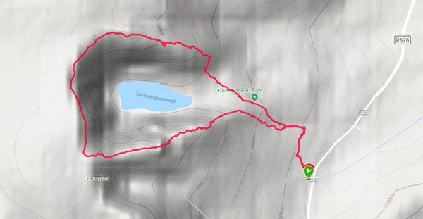
Coumshingaun Lough Loop
One of my favourite hikes this year. The variety of terrain, the views and challenge of this hike made for a great day out.
Located on the east of the Comeragh Mountains, the Coumshingaun Loop is an 8 kilometre loop that I would consider moderate in difficulty. For the most part the path is clearly visible, but in spots it would be prudent to know your route ahead of time. I used my Garmin to ensure I kept on track, but a map and compass will do just fine. The route is very popular and on good days you will see plenty of hikers to follow if you're unsure.

Starting with a short walk through the forest to meet up with the trail, most people I've talked to recommended heading clockwise around the loop, starting on the south. I prefered the north, anti-clockwise direction as it had a more gradual climb to begin with. This did have the advantage of having a scramble down on the way back which I prefer as I can clearly see the route. We had to help novice scramblers on their way up who couldn't clearly see the way up.

Once you reach the top of the first peak, a great spot for lunch among the rocky pillars, you'll be treated to a lovely flat walk around the horseshoe with epic views of the lake and cliffs along the way. A head for heights is needed in a few spots, but the pictures you'll take are worth it.
This flat section can be very wet and boggy in parts, so waterproof footwear and good socks are a must. This is also true for the decent as the scramble and the rocky terrain can easily lead to twisted ancles. Although this for me was the best part, jumping around rocky outcrops and boulders.
At this point I broke out my stove for a second lunch and hot coffee perched on top of a gully with a spectacular dropping view of the lake was had. We were there to enjoy ourselves after all! 
The path seems to disappear after the final decent from the mountain, but if you head for the edge of the forest you'll pick up the path you started on and back to the carpark.
All in all a great hike, tricky in places, but worth it. Bring plenty of water and snacks, and give around 4 hours for he hike. Enjoy!

